
About Us
Our Vision
FACE Technology and Engineering, a pioneering R&D company at the forefront of climate services. Established in 2020, we blend science and technology to deliver cutting-edge solutions to vital sectors. Our mission is to empower businesses and organizations to effectively combat climate challenges by providing them with high-resolution climate data, advanced modeling tools, and actionable insights.
What We Do
FACE Engineering bridges science and technology to provide innovative solutions across a range of critical sectors, including:
-
Renewable Energy: Comprehensive assessments and modeling for sustainable energy projects.
-
Water Resources Management: Advanced tools for water quality, quantity, and resource optimization.
-
Hydraulic and Hydrological Modeling: High-resolution models for flood risk, hydrology, and watershed analysis.
-
Remote Sensing and Earth Observation: Leveraging satellite data to monitor and analyze environmental changes.
-
Software Development: Custom solutions for spatial data analysis, visualization, and decision-making.
-
Climate Change Adaptation: Tailored strategies to mitigate and adapt to climate risks.
Product Stack
Our Products
Explore our ongoing research initiatives focused on addressing climate change and its impacts. Our products aim to create innovative solutions for various industries, supporting them in adapting to a changing climate and reducing environmental footprints.

High-Resolution, Site-Specific Climate Data
Climate Risk & Scenario Analysis
We deliver downscaled, bias-corrected, multi-model ensemble of CMIP 6 climate projections with unprecedented accuracy and ~6 km spatial resolution, tailored specifically for Turkey.
This level of detail empowers clients to make precise, localized risk assessments for any region or project.
Bias-corrected and downscaled ACCESS-CM2 model output for near-surface air temperature over Turkey: Left panel shows the downscaled dataset (0.055° resolution), while the right panel displays the original dataset (0.25° resolution).
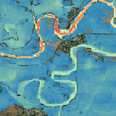
Country-Scale Flood Modeling
Turkey scale flood map to provide risk professionals with all perils and climate options
Our flood modeling provides 30-meter resolution maps, climate-conditioned for any future scenario up to 2100.
The flexibility to simulate floods for multiple return periods (2 to 1000 years) ensures users can prepare for a wide range of scenarios, supported by local validation.


The Power of Precision: 40 Years of High-Accuracy Precipitation Data for Turkey
Accuracy. Innovation. Impact.
Experience the future of precipitation data—built for Turkey, ready for the world.
Our revolutionary gridded daily precipitation dataset, blending over 1,000 ground stations with satellite technology using cutting-edge machine learning. Spanning an unparalleled 40 years and outperforms all available alternatives. This dataset delivers precise, reliable insights for climate studies, hydrology, flood analysis, and more.
Services

Climate Services
Management/analysis of climate-related risks
Climate Data/Scenario Analysis
Physical Climate Risk Assessment
Impact of climate change on the energy sector and sustainable development of cities

Hydraulic and Hydrological Modeling
Flood Hazard and Risk Modeling
Short, Medium, and Long-Term Flow Forecasting
Custom Solutions for Flood-Related Needs: Designed for insurance companies, government agencies, and emergency management organizations.

Remote Sensing and Geospatial Information Technologies
We specialize in leveraging cutting-edge geospatial technologies to monitor and analyze key hydrological variables. Our expertise includes:
Satellite Data Processing
Algorithm Development
Geospatial Data Analysis and Database Design


